tl;dr
To map a cellphone tower that mimics a tree, cactus, or another natural or man-made object in OpenStreetMap use, for example:
man_made=mast
tower:type=communication
mimics=palm
A list of known values may be found at Key:mimics and can be expanded as new cases arise.
Traveled deliciously in 2019. Nearly a year ago, in February, I flew to Paris for a few days; visited Bristol, Farnham, London, Glasgow, and Edinburgh; flew to and spent a week in Amsterdam; headed home and, due to a late Lufthansa flight and the resulting missed connection, was given the gift of 24 hours in Munich.
Trip would not have happened if not for the Sensory Moving Image Archive (SEMIA) Symposium, a unique gathering of people involved in the visualization, exploration, and reuse of moving image data. I’d hesitantly submitted an abstract after a call was posted to the FrameWorks list and was thrilled when my presentation was accepted and slotted into the Data Visualization and Experimental Film and Video session, following Carleen Maur.
You give talks. Exchange contact information. Forge social media connections. In this case, Carleen and I became friends on Facebook. In November she posted about a project where she’s been mapping cell towers camouflaged as trees across the south, especially in Florida, Georgia, and the Carolinas. This caught my attention for two reasons: 1) mapping, a friend of mine’s mapping and 2) those simulacra.
These monstrosities have captured a lot of people’s attention since they began sprouting up in the early 1990s; a hasty sampling of articles include Kurt Kohlstedt’s Botanical Imperative: Why Cellular Network Towers Get Disguised as Trees for 99% Invisible, Joseph Stromberg’s The bizarre history of cellphone towers disguised as trees for Vox, and Julian Oliver’s Stealth Infrastructure, a technical exposé and critique that appeared in Rhizome.
For the visually inclined, nice photo roundups include Lauren Young’s Take a Look at America’s Least Convincing Cell Phone Tower Trees in Atlas Obscura, BoredPanda’s Cell Phone Towers Disguised as Trees, and W.P. Armstrong’s tongue-in-cheek Cell Phone Trees: Fake Trees Are Springing Up Across America. Obsessive directories include Dr. Jonathan Kramer’s Cell Tower Photo Gallery and Disguised Cell Towers - A Waymarking.com Category, and the catalogs of the companies that build these structures are well worth a look: Cell Trees, Inc., Raycap | STEALTH®, and Valmont® Structures (formerly Larson Camouflage).
My kneejerk reaction was encouraging Carleen to both exploit and contribute to OpenStreetMap rather than devising a private map log. And that turned into a lengthier process than expected.
Finding one’s way with into OpenStreetMap
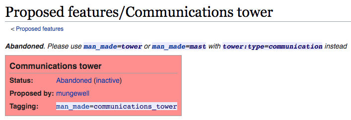
I started with a Google search on openstreetmap camouflaged cell tower tagging. Top result: an OSM wiki page called Proposed features/Communications tower. I didn’t need to read past the first line of that page.
Let’s look at these tags.
A man_made=mast is narrow, often a single mast of concrete or steel, with ladder steps for access; it may be supported by guy wires. A man_made=tower can be built from wood, steel, brick, stone or concrete, and provides platforms along the access route. Larger still and not applicable to the topic at hand is the man_made=communications_tower which is taller than 100 meters, has stairs, likely an elevator, and contains transmission facilities in the dome. The photographs in the section on distinguishing kinds of communication towers are succinct and illustrative.
Two other items of note on those wiki pages. The sidebar to the right mentions that man_made=mast should only be applied to nodes while man_made=tower can legitimately be applied to nodes or areas; this will be relevant in our query development. The taginfo callout shows the number of times the tag appears in the planetwide OpenStreetMap database (and can reveal incorrect uses of the tag). As I write this, there are 101,608 nodes tagged man_made=mast (with 664 incorrectly tagged ways and 2 incorrect relations) as well as 222,231 nodes and 45,810 areas tagged man_made=tower (with 519 incorrectly tagged relations). To be clear: those quantities are all masts and towers, not just cellphone service infrastructure.
Final remark. When I started looking into this the OSM wiki recommended adding tower:construction=concealed for camouflaged masts and towers.
Extracting data from OpenStreetMap
overpass turbo is an open, widely-used service for querying OpenStreetMap data. It can be cryptic for the new or occasional user but the interface includes a helpful wizard to get started. Tutorials can be easily found via search and a promising new User’s Manual is being drafted and translated.
Based on the tag research in the previous section I expected this query to spew forth many examples of camouflaged cellphone towers in the United States–
[out:json][timeout:120];
(
  // Limit the search to the United States.
  {{geocodeArea:"United States"}}->.a;

  // Search for properly tagged cellphone masts
  node
  ["man_made"="mast"]
  ["tower:type"="communication"]
  ["tower:construction"="concealed"]
  (area.a)
  ;

  // Search for properly tagged cellphone towers
  node
  ["man_made"="tower"]
  ["tower:type"="communication"]
  ["tower:construction"="concealed"]
  (area.a)
  ;

  area
  ["man_made"="tower"]
  ["tower:type"="communication"]
  ["tower:construction"="concealed"]
  (area.a)
  ;

  // Combine sets of output
  (
    ._;
    >;
  );
);
out body;
>;
out skel qt;
–but of the 90-ish entities returned only one seemed to be an example of what I was looking for (it contained the key-value pair "note": "pine tree"). So much for part one of my recommendation to Carleen; OpenStreetMap had nothing to exploit!
The OpenStreetMap Proposal Process
The process of introducing new tags into OpenStreetMap is well-documented, as is the progression of what became the mimics key:
- the initial inquiry on the Tagging email list as to how (or if) the objects were tagged
- the proposal, now archived, for
Key:mimics - the request for comments on the Tagging email list
- the call for votes
- the results of the vote
- the approved & active
Key:mimicspage
A few highlights and observations.
One taxonomy of camouflage lists three principles: crypsis, mimesis, and motion dazzle. “Crypsis”, and to some extent, “motion dazzle”, are specialized terms not common in everyday speech. Not so “mimics”, which seemed a better tag than alternatives such as “disguised_as”, “camouflaged_as”, or “looks_like”. It is an unusual tag in that it is a verb.
It became clear through discussion that the practice of tagging camouflaged structures tower:construction=concealed should be discontinued, partly because the construction key is better served when limited to materials and form, and partly because even when telcommunications equipment is concealed, the structures often call attention to themselves by being oversized and overly-symmetric. The practice has been deprecated.
It was also interesting to hear from one mapper that–
People, including me, who add cell towers very likely have no idea that anybody carees [sic] that they have fake branches on them, and don't consider this all that interesting and don't bother to tag it. The presence of fake branches simply means "the local Planning Board or Zoning Board of Appeals required fake branches, and the cell company decided that paying for fake branches was cheaper than arguing about it".
–just to underscore the different motivations across OSM mappers.
The results of the vote was 21 yes, 0 no, and 3 abstentions.
Using mimics
In 2013 it was estimated that there were between 1,000 and 2,000 such structures in the United States alone. How do we get near those numbers now that a schema’s been agreed upon?
I celebrated New Year’s a few days early this year by going on an epic, for me, 54 mile bicycle ride. My riding partner dubbed it “four counties, three bridges, two cyclists, and a bus”.
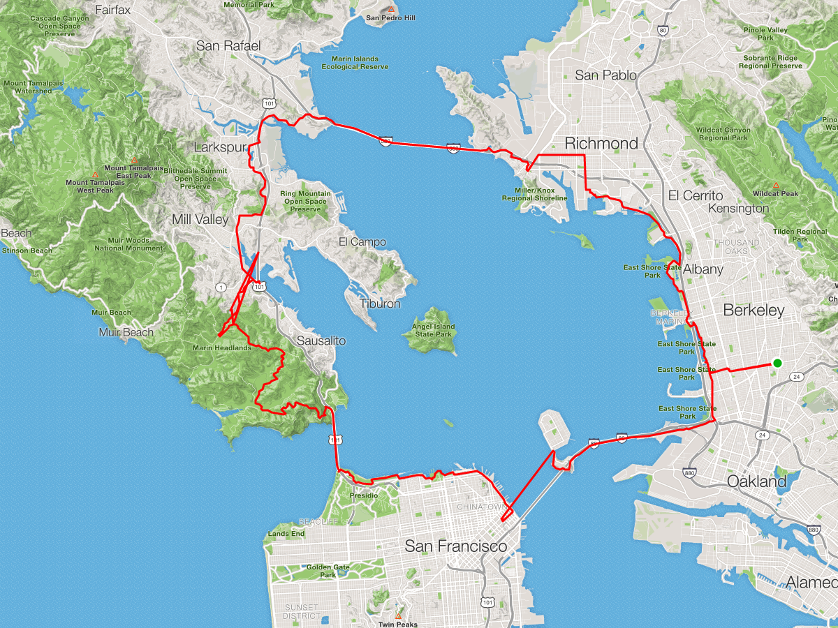
The first in our “bridge trifecta” was the Richmond-San Rafael Bridge, whose bike lane had only opened a month earlier. As we were about to turn right near The Plunge I spied a specimen on the ridge over Pt. Richmond.
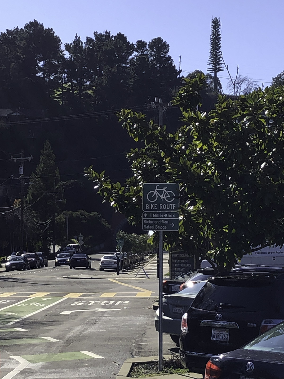
After recovering from the ride I logged in to see if it was already in OpenStreetMap; I navigated to The Plunge, clicked Edit to trigger satellite imagery, then swiped to the south-southwest along Dorman Drive until–
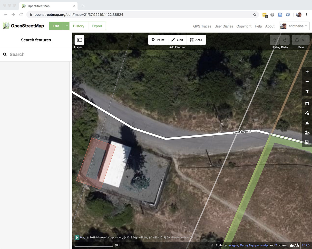
–an unnaturally long and straight shadow appeared. Bingo. Note that there’s a building outline, some roads and administrative lines but that the cellphone tower is not yet known to OSM. My next steps were to:
- click
Point(point being equivalent to node) - click the center of the tower
- select the feature type by searching for
mast, then clickMobile Phone Mastfrom the list of results - use the
+under All tags (3) to addmimics, thenpine
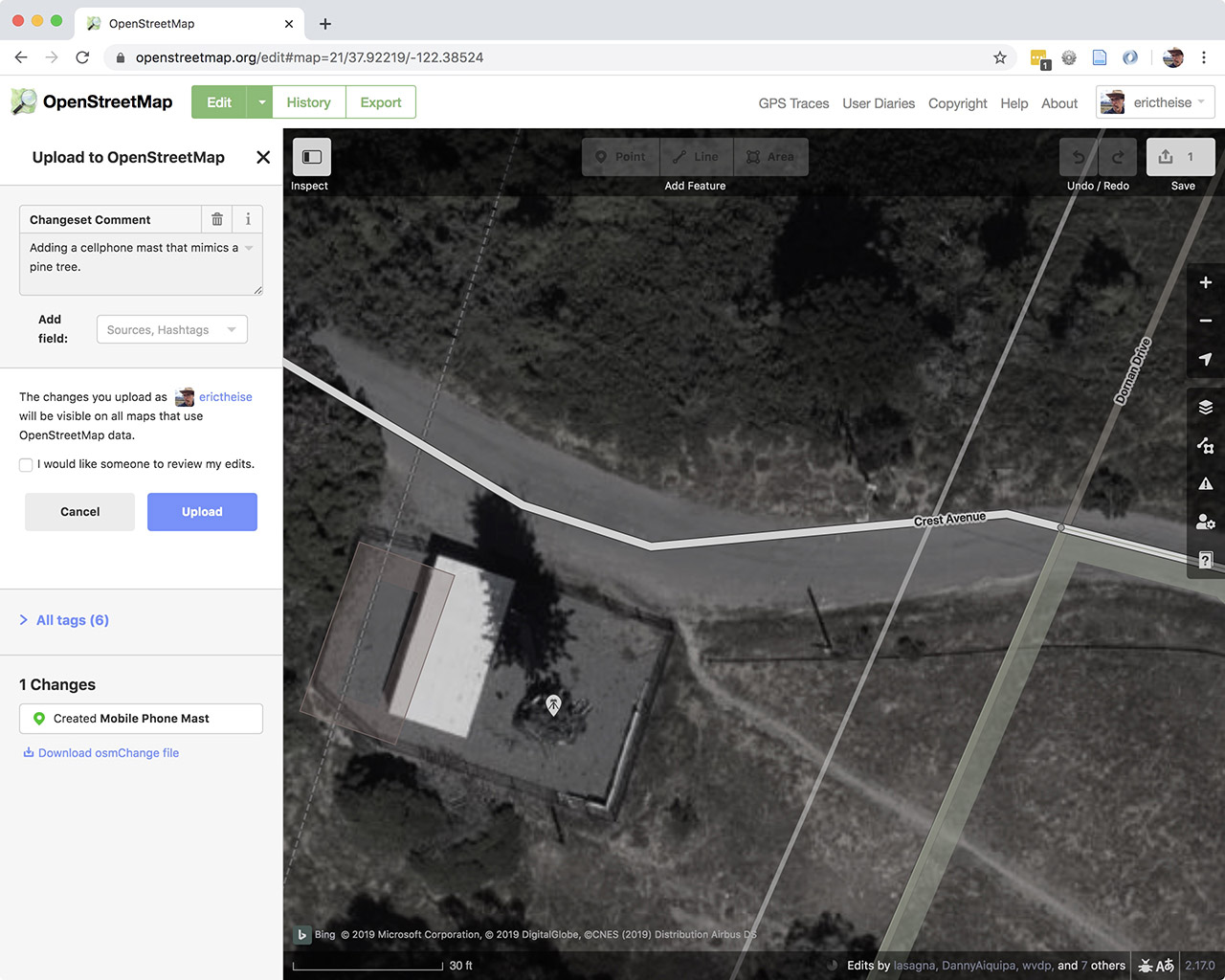
If I’d known technical details about the telecommunications equipment, or been close enough to feel confident adding more details concerning its construction, this would have been the time to add it. I clicked Save, provided a Changeset Comment, and clicked Upload.
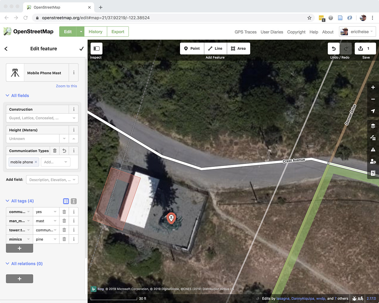
Done. Note that by selecting Mobile Phone Mast using iD, the in-browser editor, three tags are pre-filled:
communication:mobile_phone=yes
man_made=mast
tower:type=communication
If this cellphone tower had already been in OpenStreetMap my edits would have been twofold: adding mimics if it wasn’t already there and trashing tower:construction=concealed if it was as that practice is no longer recommended.
Photographer friend Pete Mauney, who logs many miles seeking locations from which to shoot his Airplanes series, responded to my request for examples by directing me to one at the interchange between Route 17 and East Allendale in New Jersey, of which he writes “oddly, it seems to have been disguised as a dead pine tree. Maybe some sort of parasite?”
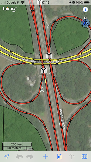
It's convenient to map while mobile and the OpenStreetMap ecosystem has a number of iOS and Android applications that allow for varying degrees of contribution. I've tried a few for iOS, settled on Go Map!!, and the screenshots to follow are from that app. Here's that cloverleaf (a three leaf clover).
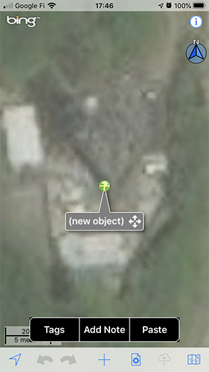
As in the case of the Pt. Richmond pine, the structure is relatively easy to find due to its unnaturally long, straight shadow. After zooming in and bringing it into the crosshairs, a click on the + prompts a (new object) dialogue.

The Go Maps!! pane for Common Tags is usually adequate for mapping tasks but in this case, I needed to switch to the All Tags pane. Searching for mast prepopulates a few tag values and, as before, it's easy to add mimics.
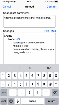
I keyed in a simple Changeset comment, then tapped Commit.
Done.
Extraction revisited
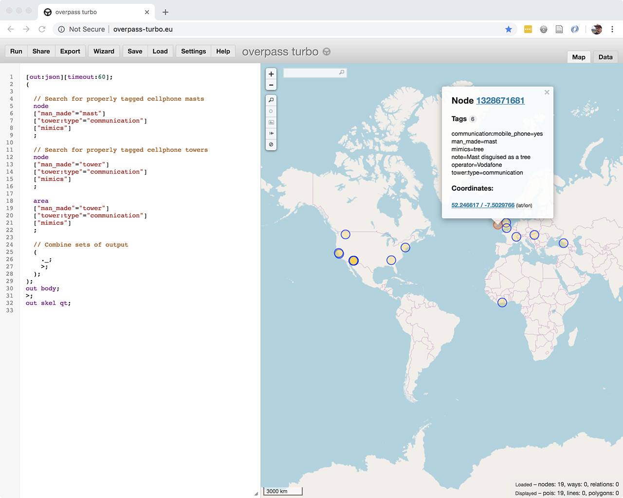
I revised the earlier overpass turbo query by dropping the ["tower:construction"="concealed"] condition and checking for the presence of the mimics tag.
[out:json][timeout:120];
(

  // Search for properly tagged cellphone masts
  node
  ["man_made"="mast"]
  ["tower:type"="communication"]
  ["mimics"]
  ;

  // Search for properly tagged cellphone towers
  node
  ["man_made"="tower"]
  ["tower:type"="communication"]
  ["mimics"]
  ;

  area
  ["man_made"="tower"]
  ["tower:type"="communication"]
  ["mimics"]
  ;

  // Combine sets of output
  (
    ._;
    >;
  );
);
out body;
>;
out skel qt;
The tag’s been active for about a month and it’s somewhat heartening to see 19 tagged masts and towers on multiple continents. I’ll look forward to a day when there are ten times that number, and then again ten times that.